
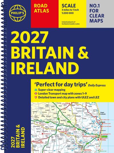
Philip’s 2027 Road Atlas Britain & Ireland: Spiral A4 Edition
£16.99
‘Good balance between detail and clarity with excellent town maps’ What Car?’Perfect for Daytrips’ Daily ExpressPHILIP’S – Market leader and No. 1 in the UK for clear maps 2027 Philip’s Road Atlas of Britain and Ireland is a top-of-the-range, A4-sized, spiral-bound atlas, featuring fully updated maps from the Philip’s digital database. Voted Britain’s clearest and most detailed in an independent consumer survey, the mapping is super-clear.* SUPER-CLEAR ROAD MAPS – 160 pages of fully updated maps* TOP TIPS for better and safer driving and the easiest way to parallel park * DETAILED ROUTE-PLANNING maps, to help plan your route in advance* 88 fully indexed and DETAILED TOWN-CENTRE maps with low-emission zones marked* Major city approach maps with named arterial roads including the expanded London ULEZ* Clear road map showing all of Ireland * Mapping at a scale of 3 miles to 1 inch = 1:200,000 for easy use* Handy lie-flat spiral format* Lon
In stock
'Good balance between detail and clarity with excellent town maps' What Car?
'Perfect for Daytrips' Daily Express
PHILIP'S – Market leader and No. 1 in the UK for clear maps 2027 Philip's Road Atlas of Britain and Ireland is a top-of-the-range, A4-sized, spiral-bound atlas, featuring fully updated maps from the Philip's digital database. Voted Britain's clearest and most detailed in an independent consumer survey, the mapping is super-clear.
* SUPER-CLEAR ROAD MAPS – 160 pages of fully updated maps
* TOP TIPS for better and safer driving and the easiest way to parallel park
* DETAILED ROUTE-PLANNING maps, to help plan your route in advance
* 88 fully indexed and DETAILED TOWN-CENTRE maps with low-emission zones marked
* Major city approach maps with named arterial roads including the expanded London ULEZ
* Clear road map showing all of Ireland
* Mapping at a scale of 3 miles to 1 inch = 1:200,000 for easy use
* Handy lie-flat spiral format
* London Transport map zones 1-9
This atlas contains 160 pages of road maps covering Britain at 3 miles to 1 inch, with the Western Isles, Orkney and Shetland at smaller scales. The maps clearly mark service areas, roundabouts and multi-level junctions, and in rural areas distinguish between roads over and under 4 metres wide.It also includes a 2-page road map of Ireland, 10 pages of route-planning maps, a distance table, London Transport map, 10 large-scale city approach maps with named arterial roads, and 88 extra-detailed and fully indexed town and city plans.
Wherever you are driving in Britain and Ireland, this is the ultimate road trip guide.
| Dimensions | 29.8 × 21.7 cm |
|---|---|
| Author | |
| Publisher | |
| Imprint | |
| Cover | Other |
| Pages | 256 |
| Language | English |
| Edition | |
| Dewey | |
| Readership | General – Trade / Code: K |
Related products

TRAVEL

TRAVEL

TRAVEL
TRAVEL
TRAVEL

TRAVEL